
Words by Elaine, photos and captions by Dan.

This is it, the big one, the one we’ve all been waiting for!
Sure, Fred and George Weasley may have forever engrained these words into many a millennial’s mind, but they sure seemed fitting as we headed into this last, and wildest, section of the Great Divide Trail.
I wasn’t sure it was going to happen. Dan and I arrived in Valemount, where we were resupplying for the last section, just fine – eating burgers, happy to dry out. That night, I woke up with the worst, wrenching stomach cramps. For 12 hours, I couldn’t stray far from the bathroom, and at one point, was stretched out on the balcony outside our room, sweating and shaking, wondering if I was going to die. (Yes, I’m a very dramatic sick person). Then, magically, that night I ate a whole pizza and packed up. I still have no idea what happened, but I was very grateful it passed quickly.
August 13th – Back into the Woods – 7 miles, 1,400′ gain
In Valemount, we met Mik again and realized that we were on a similar schedule. Their mom was coming to pick them up and offered us a ride as well. The trail ends, and then there is a 100km road walk out to a highway where you have to hitch from. This is Highway 16, which is also nicknamed the “Highway of Tears” because of a series of rapes and murders that have happened along it in the past 30 years. Now, these have actually happened between Prince George and Prince Rupert, which are quite far away from where we would be coming out on the highway, and the victims are by and large natives, but regardless, it was still a very disconcerting thing to know. Long story short, we decided to go through the last section together.

Dan and I began hitching out of Valemount in the afternoon, and had a lucky hitch – a gentleman in a van pulled over almost as soon as we stood on the highway. He had seen our sign saying “Mount Robson”, and was heading there, so instead of what is usually a two-part hitch, we got the ride all in one.
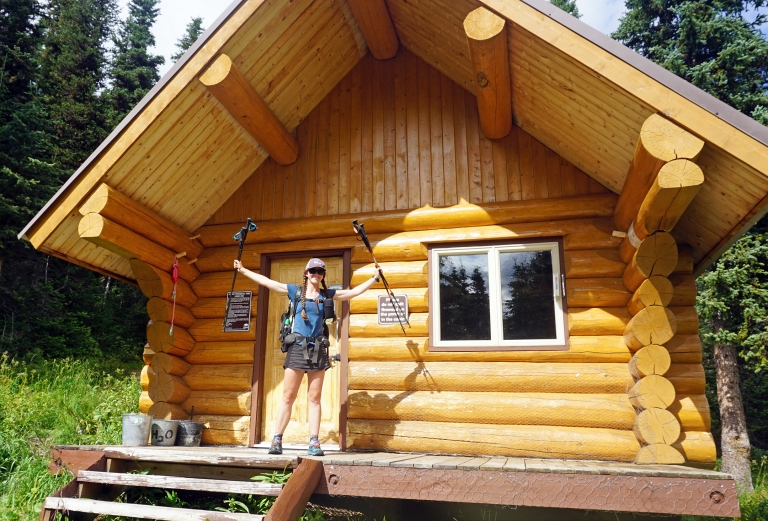
As we started up the Berg Lake Trail, weighed down by our packs filled to bursting with our ten day resupply, we marveled at the difference good trail makes. The Great Divide Trail is, more often than not, on what would be more likely called a “path”, or even just cross country travel. With the Berg Lake Trail built to accommodate the traffic from so many people, we could cruise along fairly easily.
Arriving at the Whitehorn campground, where our reservation was for the night, we scoped a few spots, then chose one a bit further away from the main spread of tents, with an extra pad nearby in case Mik showed up. Taking our Subway sandwiches (it’s a nice break from freeze-dried food on that first night) down to the cook area, we soon struck up conversation with a family that had brought their kids up for a five-day trip. They had seen us coming down as they were going up, and so were confused as to what we were doing. We chatted for a while before everyone began to drift away to bed.
Dan and I stayed up for a while, watching the many waterfalls cascading down the cliffs around us as the sun set. It was hard to believe that the end of the hike was coming, and I felt a great swell of sadness. Some people say that the end of a trail gets easier the more you do it…I’m not sure that’s true for me. The more I stay out in this world, the harder it seems to be to come back to the hustle and bustle of civilization.

August 14th – Onto the North Boundary Trail, Into the Wild – 17.4 miles, 2,400′ gain
One of the things I love the most about backpacking is how amazing I sleep out here. I woke up that morning with no memory of even turning over in my sleep – however, as soon as I sat up, something felt wrong. I wriggled around in my sleeping bag to take a look at my sleeping mat, and immediately felt my heart sink. I use a blow up air mattress, one that has served me well for many thousands of miles. Punctures are a bit par for the course, though because I’m careful, I rarely get those. This, this was not a puncture – a baffle had blown, a phenomenon I’d only ever heard of when it comes to air mattresses, never seen, and it created an awkward bubble up by my head. As there was nothing I could do about it, I shrugged and we packed up and began the climb back up to Berg Lake and Mount Robson.
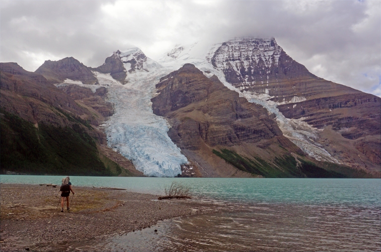

I’d been dreading this climb a bit, with the large packs, but because the trail was so well built, and the scenery was beautifully distracting, Dan and I were at Berg Lake before we knew it. Unlike the last time we had been there, blue skies reigned, and as we spread out by the lake to watch the mountain and wait for Mik, we got to bask in all its glory. While we waited, we pulled out our food, and again went over how much we had. Obviously it’s not our first time doing this, but it was very hard to banish the niggling doubts that we didn’t have enough. As we spread out the piles of food around us, other hikers came by to ask what we were doing with all that food. It is a funny experience to try to describe a hike that goes to place no one has ever heard of!


Mik arrived and we headed off again, eventually rejoining the Great Divide Trail, where we half-jokingly, half-seriously made an offering to the trail. It’s easy to get superstitious out here, and what with the weather we’d had, overconfidence was not a problem. For this section, we followed the old, decommissioned North Boundary Trail for a ways. It was a section I’d been dreading, as Jasper National Park is decommissioning trails everywhere, and the decommissioned trails are pretty horrible. However, the North Boundary Trail was still in pretty good shape: there was deadfall, but not enough to really slow us, and the trail was swampy and muddy, but nowhere near what we’d encountered in places from Jasper to Mount Robson.


We called it a day in a dense, murky forest, towering pine trees draped in old man’s beard leering over us as we pitched our tents on the mossy ground and walked 100 meters down the trail to cook supper.
Dan gave me a beautiful pair of earrings he’d picked up in Valemount, carved from birch found in the area, and when they found out it was my birthday, Mik gave me a piece of their chocolate for desert. Curled up in our tents that evening, an owl serenaded us to sleep, I knew there was nowhere else I’d rather be than there in the moss.

August 15th – Jasper’s Parting Gift…Torrential Rain – 14.4 miles, 3,400′ gain
The thrush bird ushered us into the day that morning, its powerful call ringing through the quiet woods. Once again, it was a fabulous night’s sleep, despite another baffle fully blowing on my mat, creating an even larger big air bubble.

We traipsed through the lush mossy forest, absorbing the steady thrum of life emanating from it. Mount Robson lays east of the coast, obviously, but very few to no mountain ranges are directly between it and the coast, so the area is very wet, almost coastal, to the point of cedars growing down low.

We reached the Chown river – another river that has been known to cause problems, and where we would leave the North Boundary Trail. We took our first snack break by the river to discuss what we wanted to do. The trail technically crosses, goes up river a few kilometers, and then crosses again, so you could either cross it twice, or not at all. As the trail was once again more what one would describe as a “footpath” at best, and the Chown was looking rather full (with the wet summer, rivers are running high), we all decided to keep to our bank. At first we headed up the flood plain – easy traveling on bare rocky ground – until we were forced up into the woods. Progress slowed dramtically here, as we clambered over, under, and between deadfall. Finally, we reached the point where the trail crossed back over, and movement became a bit simpler.


As we started up Bess Pass, we began a singing game where one person would sing a couplet from a song, and then choose a word from that phrase, and then someone else would sing a song with that word in it. This was great fun, and covered a fair amount of distance for us, as we laughed hard. This turned out to be a bad idea – the excess energy used to belt out songs and double up with laughter moved our typical snack time up an hour, and we sobered up after that – none of us had brought enough food to carry on with that.

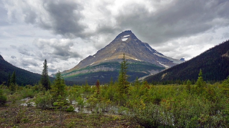
We passed under Chown Glacier – a vast glacier stretching out widely above us, and the source of many waterfalls all around. The trail deteriorated, becoming a muddy mess that caused each step to slip back half of what we gained. Cresting Bess Pass, sweeping views lay out before us, every peak sporting a glacier.


As we reached Jackpine horse camp, heavy rain moved in, and we all layered into our rain gear before heading up Jackpine Pass. We set up camp in the rolling alpine, quick efficiency the name of the game with the threat of hypothermia looming in the cold rain. But once again we were tucked into our cozy tent and it was cuddly warm.

August 16 – Onto the Jack Pine Alternate – 16 miles, 4,600′ gain
Rain poured all night long, with snow on the peaks just above where we camped, and I was grateful that we were camped on mostly slate rock with the hopes that it would drain well. It was a tough morning to get going, cold, wet, and foggy, so the three of us slowly meandered through a complicated terrain of tarns, ridges, and moraines. It’s interesting, traveling with someone else. Dan and I have almost exclusively traveled together for so many years now, we’re about as close to functioning as one person as two can be. Generally, we need to shed/add layers at the same time, take a break at the same time, all of the little stops that slow a group down, over the years, we’ve adjusted so that we’re really only stopping the same amount one person would. Adding another human into the mix is an interesting experience, and definitely one that is taking some getting used to.


The sun came out for a bit, so we took a snack break on a ridge above Blueberry Lake. Heading down to it, we hit surprisingly good trail that lasted until we hit bog again. Picking our way through it, we reached where the official trail dropped down into the Jackpine Valley to follow Jackpine River. The Perseverance High Route Alternate went off to our left, following a very high, completely cross-country route, 10km longer, and with a lot more elevation gain. However, the Jackpine River comes with quite the reputation – one hiker has dubbed it “The Valley of Sadness” for it’s bushwhacking through willows, mud, lack of trail, and general ickiness.


Though the clouds were still overhead, and the forecast wasn’t great, we headed up the alternate, knowing that there were several places we could bail off if the weather moved in. Immediately, we discovered that while the map showed us traipsing in a straight line across the tundra, the actual terrain was more complicated than that, involving us cutting straight across several very deep troughs and ridges, rising like waves perpendicular to the mountainside.


We experienced another snafu when it came to navigation. Dan and I have honed a system over the years where he will do the macro navigation from the back, pointing out our general heading, and I do the micro navigation from the front, choosing the line to get there. Mik had been traveling solo, so had been doing it all. After several failed attempts at swapping responsibilities around, we settled on a similar arrangement that Dan and I usually use, especially as Mik’s knee began to act up more and more as the terrain grew more steep and technical.


The rest of the day involved navigating up long ridges and down several tricky cliff bands, where Dan rolled his ankle pretty badly and in an unusual way, rolling it over itself to the inside. It didn’t bother him much at the time, and we continued onward. Eventually we reached a set of tarns where we set up camp, very far away from each other due to the scarcity of semi-flat spaces.

August 17th – Perseverance, Storms and Heinous Bushwhacks – 12 miles, 4,500′ gain
This was the first night my mat really hindering my sleep. Another couple baffles blew, and while there was a sense of dread when I hear it happening before I’ve fallen asleep, it was quite shocking and loud after I’d fallen asleep! Dan also woke up to find that the ankle he had rolled the day before was feeling useless. He could hardly weight it, and said it was throbbing as we sat there. There’s not much we can do out here though, so I went over it as best I could – assessing for swelling, which there was very little and no bruising. While Dan visualized his ankle healing rapidly, I taped him up and had him take several ibuprofen tablets combined with a caffeine pill in the hopes of managing the pain properly.


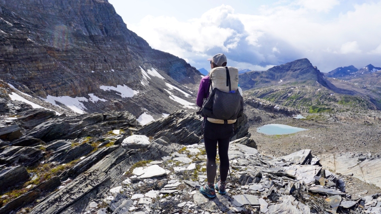
Mik joined us and we began climbing up to our next pass via sweeping slabs of rock. Dan’s ankle began to feel a bit better as we climbed and by the time we crested a snowfield to the pass, nestled in between two glaciers, he was walking fairly normally. Another curiosity with our maps occurred here, as we gazed down the talus-filled valley at two lakes that very clearly were there in real life and not on the maps. We navigated the challenging, steep talus down to the lakes, and then climbed up a ridge above the lakes where we chose our route very carefully and slowly down a series of cliff bands and waterfalls to the valley below. The beauty was stunning, but the attention required to not slip over the cliffs prevented any of us from taking many.


Eventually, we reached another talus-covered slope, this one much gentler, and now covered in rain-soaked lichen and moss, making footing even more tricky. As we began climbing up to another ridge, the wind began to pick up, whipping our backpack straps around and blowing hats off. We walked along the ridge for a while before navigating down some more little cliff bands to a creek at the base of Perseverance Mountain. We filled up on water and began the very steep climb up it. It was a grind, just trying to keep it moving, but I loved it.


As we reached the top, the wind continued, whistling around our ears, bringing rain this time. We eyed our ridge, and the six peaks along it that we would climb on the route as we donned our rain gear. As we worked our way up and over the first one, the storm moved in stronger, the by-now familiar white wall of heavy rain advancing on us. The weather was rapidly deteriorating, the rock was getting very slick and travel was slow. We hunkered down in a little pass between peaks, debating what to do, eventually deciding to bail on the high route.


At first, as we descended, it was relatively easy travel on crushed scree, then across soggy tundra, but soon we hit a dense woods. There was nothing to do but put our heads down and keep going, each retreating into our own little suffer bubbles. Eventually we reached the Jackpine River and the official trail, or what little of it there was. It was in a bit of a depressed state that we all set up camp that night.
The woods here were so dense, it was almost dark, and we were so exhausted that getting water for dinner almost turned into a disaster. The woods were extremely disorienting, and by the time we found water we had little idea of which way to go to get back to camp. We grabbed the GPS and headed in the general direction of where we thought we should be, yelling loudly, hoping for a reply from Mik.

After repeating this a dozen times, we finally heard a return call, and followed the sound to camp. Ten minutes later, Mike repeated the same process to get water, and a similarly harrowing experience in these very dense, very claustrophobic woods.
August 18th – Over Slate Mountain and Into the Willmore – 14 miles, 5,300′ gain
The mattress reached an unfortunate place that night. For the first half of the night, I fought with it, the bubble now so pronounced that I could barely stay on it, slipping off to one side or the other, or else ending up with my head hanging off it. Then Dan and I swapped mats so that we could each get a half night’s sleep. It rained all night again, and was still at it when we finally woke up at 8. What with the rain, and yesterday’s effort pulling sluggishly through our blood we were slow getting going. We found Mik to see they were still waking up. It was cold enough that we all agreed Dan and I would hike on and meet back up with Mik later, to avoid getting chilled.
Weird things of weird things, Dan’s ankle didn’t hurt at all.

The Jackpine valley lived up to its poor reputation, even the short amount of time we were on it (we had covered 80% of the valley via the high route before we came down), with lots of “muddy schwacking” – a trail description I had not thought to verbalize before hiking the Great Divide Trail, involving schlepping through shin deep mud while bushwhacking through bushes higher than your head. Insert a rain storm, and you have a pretty darn cold, wet situation. Dan and I climbed up the first ridge – a very steep grunt involving more slippery mud, and more bushwhacking through the rain-soaked brush. Finally, we got up high enough to emerge from the brush and the worst of the mud, long enough that we got to stretch our legs a bit before plunging back down to the valley on the other side, which was a virtual muddy slip ‘n’ slide.

At the bottom was Pauline Creek, which was over my waist in depth, but was thankfully not very fast. Thoroughly drenched at this point, we began the climb up Shale Pass. For whatever reason, when I was researching the trail, Shale Pass stuck in my head. Obviously the end point (whichever end point you choose, as this trail has three) is a big one, but Shale Pass was, for some reason, meaningful. As Dan and I climbed above treeline, we watched the white curtain of rain in the distance getting closer and closer to us, the wind buffeting us along, and then, miraculously, that curtain of rain just passed us.

We descended to a little boggy valley, then back up some more before deciding to call it a day and wait for Mik to show up. That evening, as the three of us huddled around our little cook stoves, we bemoaned the mud and rain and wet, while simultaneously being thrilled to be there.
August 19th – Across the Wild Wilmore Wilderness – 21.3 miles, 3,300′ gain

In Jasper, when we stayed with the British couple who had done the Great Divide Trail, they had told us that after Shale Pass, “you fly.” As pretty much nowhere on this trail has even remotely involved that sensation, we decided to start hiking at 7 am that day, to try and catch up on some of the miles that we’d lost on previous days. The trail started with expanses of boggy sections that were sprinkled with forested sections of magical, beautiful, perfect trail. As we began to climb up our first pass of the day, the sun popped out, so we took advantage of it and stopped to dry stuff. Mik’s tent works much better when it gets the chance to dry (using a mid, Dan and I don’t have to deal with that), and everyone’s sleeping bag was getting a bit soggy.


After, we passed a plaque for the Willmore Wilderness Wanderers – a group of people out of Grand Cache east of here that apparently spends a lot of time exploring this area. Then we descended to more wet boggy land, then up a beautiful climb to Fetherstonhaugh Pass, where we had a fantastic view. We took second snack break here, absorbing all the beauty around us.


We ended up camping at Sheep Creek – another horse camp. I very much dislike the horse camps, with all the horse poop and how icky they feel. But we spent a beautiful evening watching the sun set on the cliffs around us.

August 20th – Surprise Pass and the Providence Alternate – 17 miles, 5,000′ gain
Dan and I woke up early again to get hiking – we were planning on doing the Surprise Alternate, while Mik had been planning on sticking to the trail. As we left camp, Mik informed us that after reading the trail description, they were probably going to try and do the Surprise Alternate as well. We also discussed traveling apart that day – Mik had started solo, and for Dan and me, we had first embarked on this adventure way down south at the 29th parallel at the New Mexico/Mexico border, so all of us felt the need to spend the last true day on the trail as we had started.

The trail quickly left Sheep Creek and we began a gradual climb up to Surprise Pass, following a vast alpine valley up. There were caribou prints on the trail, and we kept our eyes peeled, but we didn’t see any caribou. Just on the other side of Surprise Pass, the trail continued down valley and we cut cross-country to hug glacier line at the base of Wallbridge Mountain.


Up there, we met incredible, complicated, rolling glacial terrain. Enjoying the moment, we took an extremely long first snack and cooked one of our extra dinners. While waiting for the water to boil, we realized that the little pebble rocks surrounding us were not, as they appeared, simply rocks, but fossilized shells from millennia past. Dan and I whiled away a good amount of time pouring over the landscape and marveling at all the fossils that were just lying there for us to see.


While waiting for our dinner to rehydrate, I spotted something moving, way back on Surprise Pass. I wondered if perhaps it was a wolf pack at first, but realized they must be larger creatures for me to be seeing them from the distance we were at. It was tough to see, but I think it was a herd of caribou – perhaps seven or so – that we watched flow across the terrain, moving as though they had wings on their feet. I’ve read their hearts are much larger than ours, and that they can cover terrain in minutes that would take us hours. We watched, breathless in awe.


We began climbing again, stopping to grab water from a high, brilliantly blue tarn, before beginning up Wapiti Mountain for real. It was a fun climb, the kind that Dan and I like – steep, but manageable, steady, long enough to find your groove. At the top, we took yet another long break, savoring the high views. The days are on countdown, now, and we desperately want to hang on to these moments.


Finally we began to descend, slow going, quite steep, with large talus that ended in a complicated cliff band to navigate. As we descended into the trees, the bugs came out in full force, biting so ferociously that we busted out the bug spray for the first time on this section. After some time, we rejoined the GDT, which soon proved to be every bit as icky as we’d been told – more mud and brush. So much so, in fact, that by the time we reached Broadview Lake, where another alternate branched off to resume a higher route, we jumped at the chance.
The Providence Pass High Route Alternate started off as a vertical climb up an old drainage, soaked moss making for some challenging footing, and the bugs on their endless quest for blood. After climbing 400 vertical meters, we were once again above treeline, the bugs died down, and we were able to traverse a steep, talus strewn slope.


We ended the day, our last night on the Great Divide Trail before beginning the 100km walk out, camped beneath Francis Peak and Broadview Mount. My heart swelled with happiness as we cooked dinner by some scrubby krummholz, gazing out at the towering, glacier-blanketed peaks before us. After messaging Mik on the InReach, we settled in to our cozy tent.


August 21st – To Kakwa Lake, Trails-End and the 54° parallel – 25 miles, 3,000′ gain

We rose to an absolutely perfect morning – just a bit of rain, and then the skies cleared as we climbed up to Mount Ruth’s shoulder, brushing along a lake before beginning a descent back down to muddy bogland. Our notes mentioned that the descent was steep, and after days with no mention of anything being steep and then consequently navigating cliff bands, I was a bit nervous, only to discover that not only was the trail not a cliff – it was actually a trail! We trundled down it, watching the glacier-robed peaks disappear behind the trees until we reached the GDT again – the muddy pit that it was.


As we meandered through the mud, I thought about endings. When we hiked the Continental Divide Trail, in some ways I thought about the end a lot. The trail was a lot easier, in a lot of ways (though a lot longer), and it allowed for the mind to wander. On this trail, I am always present. Whether it’s navigating a tough section, or just walking through mud (which is a lot tougher than it sounds), my mind was always on the moment at hand. On the CDT, I spent a lot more time literally thinking of nothing, in almost a state of moving meditation, while on the GDT, every moving moment requires thinking about what I’m doing. There are pros and cons to both, for sure. In town on the GDT, it was time to check the weather, and time to read all you could about the upcoming trail and all the alternates, and in the evenings on trail, I would be going over what we were to cover the next day. My mind never really thought about the end. I knew this section was it, but as we neared Kakwa Lake, I realized that I wasn’t ready for it. Somehow, I wasn’t prepared.


After crossing a small river, we stood on the banks of Kakwa Lake and walked 200 meters up to the 54th parallel. We took a long snack break at the lake, trying to process everything, watching the still water.


Finally, we pulled ourselves up and began the long trek out. It started out as a slightly overgrown two track, which was easy travel, and allowed us to clip along at a decent pace. As our miles per hour ticked up, I realized that this was a whole muscle group that I’d not used all summer. Road walking is a totally different movement from cross country travel.
Immediately after crossing Buchanan Creek, the skies absolutely opened up and poured. I don’t think I’ve ever seen that amount of rain before – as though a hose had been turned on us. The road itself, already so saturated from a summer of record rain, turned into a river, and beneath the coursing water, a slick clay like substance that made any footing slippery. Slowly, the rain let up, and we soon ran into Mik, who had taken refuge from the deluge under the porch of a cabin belonging to a snowmobile club.
After a while, our two track became a much better maintained road, and eventually, we set up camp, cooking supper in the middle of the unused road and catching up.
August 22nd – Road Walk Out – 31 miles, 1,100′ gain
Mik had never done a 50k day before, and this was about the most perfect conditions to do one, with smooth road, cool temperatures, and lots of water so we didn’t have to do a water carry.
We were all sodden when we got up though – shocking to think that just the other morning we were relatively dry. So much rain last night – it left the ground sopping wet, and everything was just so damp. The sleeping bag, my poofy, everything was so damp. But it was a cool morning, the road made for quick travel, and we finally have light packs.

The walk out was surprisingly enjoyable. Huge mountains with glaciers surrounded the road, and the now-turning-orange trees were starting to shed their leaves as a cool autumn breeze blew across the land, kissing its first brisk warning on our weathered hikers’ cheeks.
At one point, we got a ride from a couple surveyors who were out – I guess they’re planning on logging this section in a couple years. It made me sad for future GDT hikers, as currently, this walk out isn’t too bad. They turned off up another road, so we continued on our way out to the highway.
Every once in a while, we would round a bend and a huge shape blocked the road. But these black bears are skittish, and all they want is to eat berries, so they would ramble off as soon as we raised our arms and let loose a couple bear calls.

The end of the day dragged on, and Mik’s pain in their knee and back took a steep turn up, but between a combination of music, podcasts, and chatting, we crossed the 50k mark. Setting up camp in another marsh (I shall always remember the Great Divide Trail as when I became somewhat comfortable sleeping literally in a swamp), we began to cook our dinner in the middle of the road.
We had hiked late to get the 50k, and summer was now winding down, the sun no longer setting after 10pm,. The darkness rolled in comfortably around us, stars peaking out above as we dawdled on our last night out while we were all set about to enjoy a last cup of tea. We broke out the bottle of whiskey we had taken turns carrying from Mount Robson and passed it around, laughing at the ridiculous beast that is the Great Divide Trail.
All of a sudden, the sound of a motor came down the road, and an ATV came barreling at us. Startled, we all scrambled to move our stuff from the road, until Mik stood up to get them to stop. They were a couple who were part of the snowmobile club in Prince George that owned the cabin up the road and they were heading in for their own adventure. After chatting for a while, they drove off, cheering us on as they left.

We all lay on the road looking at the stars and laughing. Soon the topic of music came up, including John Denver. (I know…I’m a Colorado native, and I don’t like John Denver, it’s practically blasphemy to many.) And then the topic of Canadian artists, which led us to singing Justin Bieber’s “Sorry” at the top of our lungs. I can’t say I’ve ever had Bieber Fever, but “Sorry” is sure going to have a special spot in my heart from now on.
These late summer Canadian nights are crisp, though, so soon we crawled into our tents and played “Would you Rather” with the Great Divide Trail.
“Would you rather hike the GDT with Oprah or Taylor Swift?”
Oprah, obviously.
“Would you rather hike the GDT with Obama or Jesus?”
Well, Jesus – I mean, the man walked on water, it would have been a useful skill out here.
“Would you rather hike the GDT with Jesus or Dobby?”
Dobby, for sure. Who wouldn’t want a house elf out here?

August 23rd – A short walk and a ride out – 5 miles, 500′ gain
The Great Divide Trail wasn’t about to let us go easily. It rained all night and continued to rain as we packed up. On the plus side, I finally realized that if I only partially inflated my mat, I was able to sleep, so both Dan and I got a decent night’s sleep. We all packed up, marveling at our light packs, and, layered in all our rain gear, as usually, headed off down the road.
It was now a road in very good shape, and Mik’s mom had decided to come and get us, so a few miles from the highway, a little Prius appeared on the road, headlights shimmering in the rain. It was a fitting end to this summer’s GDT – rain, no fan fare, just a dirt road in the middle of nowhere, a Prius, three dirty hikers, and one mom eager to feed us. As we consumed doughnuts from Tim Hortons and Hungarian sausages, we all laughed, smiled, and ate.
As much as this trail hurt, I’m sad it’s over. The Canadian Rockies are truly amazing.
Total miles walked: 754
Total elevation: 148,300′


Great story. Loved it. Congrats on making it to Kakwa and digging deep to make the most of an incredibly wild and hard section. I’ve been through Section G three times and never done the Surprise Pass alternate, nor seen a good write up on it. It sure looks like a must-do.
I presume your pad is an Exped? Probably the UL7 Synmat? They love to pop baffles.
LikeLike
Real adventure ! rain and mud but the vistas’s and planes and plateua’s
A great big congrats. to all three basically injure free with memories that money can’t buy. Done the Robson Burg hike maybe 20 times thinking of going soon again just hoping for Gods rich sun shine for maximum enjoyment. Enjoyed reading commentary. Unfortunately your photos went plank after sometime but classic never seen by most Alberta’s and British Columbia’s SPOT MATE , Brian from LACOMBE Alberta
LikeLike
Let them sneer. Canada without Tim Hortons would not be the same. A great adventure. A mindboggling achievement. Keep trekking.
LikeLike
Great walk you two! Congrats! Your feats continue to amaze and inspire… and the time and thoughtfulness you’ve taken thru word and pic has made this educational too. Would love to hear about some of the gear used in future posts. Thank you and cheers, well done!
LikeLike
Great blog on your hike. Loved the pictures and the write up was a pleasure to read!
LikeLike
Fantastic trip, faboulous photos, highly enjoyable, best trip blog ever read!
LikeLike
Real adventure ! rain and mud but the vistas’s and planes and plateua’s
A great big congrats. to all three basically injure free with memories that money can’t buy. Done the Robson Burg hike maybe 20 times thinking of going soon again just hoping for Gods rich sun shine for maximum enjoyment. Enjoyed reading commentary. Unfortunately your photos went plank after sometime but classic never seen by most Alberta’s and British Columbia’s SPOT MATE , Brian from LACOMBE Alberta
LikeLike
This blog was a great read! And funny how I came across it. Was googling the 54th parallel for our next trip to Kakwa lake after last year we didn’t check it out! It was myself and wife that encountered your group camping on the road when we were headed into our snowmobile club cabin. It was a great chat with your group. We have dedicated a lot of time maintaining the trails towards Kakwa as well as the trail in Kakwa provincial Park. We always enjoy bumping into GDT hikers as they love to chat and tell stories of their trip!
Les L’Heureux
Kakwa park snowmobile club
LikeLike